২০ বছরের মধ্যে সবচেয়ে শক্তিশালি সৌরঝড়/মেরুজ্যোতি/অরোরা বোরেলি/নর্দান লাইট দেখতে পাওয়ার সম্ভাবনা শুক্রবার রাতে।
সৌর ঝড় পৃথিবীর বায়ুমণ্ডলে প্রবেশ করলে অরোরা বা মেরুজ্যোতির বা অরোরা দেখা যায়। উত্তর মেরুর উপর সৃষ্টি হওয়া অরোরাকে অরোরা বোরেলি ও দক্ষিন মেরুর উপর সৃষ্টি হওয়া অরোরাকে অরোরা অস্ট্রেলি নামে অবিহিত করা হয়। আজ শুক্রবার সন্ধ্যার পর থেকে ভোর পর্যন্ত ২০ বছরের মধ্যে সবচেয়ে শক্তিশালি সৌরঝড় ( মেরুজ্যোতির বা অরোরা বোরেলি (বা নর্দান লাইট)) প্রথিবীর বায়ুমণ্ডলে প্রবেশের পূর্বাভাস দিয়েছে আমেরিকান মহাকাশ গবেষণা সংস্থা নাসা।
আজ শুক্রবার সন্ধ্যার পরে অরোরা বোরেলি (বা নর্দান লাইট) দেখার আমন্ত্রণ (দুঃখের বিষয় হলও বাংলাদেশ থেকে দেখা যাবে না)। আজ সন্ধ্যার পরে পৃথিবীর উত্তর ও দক্ষিণ গোলার্ধের ৪০ ডিগ্রী উত্তর/দক্ষিণ অক্ষাংশের দেশগুলো থেকে মেরুজ্যোতির/অরোরা বোরেলি দেখা যাওয়ার সম্ভাবনা সবচেয়ে বেশি তবে ৩৫ ডিগ্রী উত্তর অক্ষাংশের দেশগুলো থেকে দেখা স্বল্প পরিমাণে দেখা যাওয়ার সম্ভাবনা রয়েছে।
মে মাসের ৮ থেকে ৯ তারিখের মধ্যে সূর্যের মধ্যে প্রচণ্ড বিস্ফোরণের কারণে (solar coronal mass ejections (CMEs)) সূর্য থেকে নির্গত রশ্মি (সৌর ঝড় নামে পরিচিত মহাকাশ বিজ্ঞানের পরিভাষায়) পৃথিবীর বায়ুমণ্ডলে দিকে অগ্রসর হচ্ছে যা আজ শুক্রবার সন্ধ্যার পরে পৃথিবীর বায়ুমণ্ডলে প্রবেশ করবে। আমেরিকার NATIONAL OCEANIC AND ATMOSPHERIC ADMINISTRATION কর্তৃক পরিচালিত SPACE WEATHER PREDICTION CENTER সেন্টার কর্তৃক পরিচালিত ওয়েবসাইটে Coronal Mass Ejections (CMEs সম্বন্ধে নিম্নোক্ত বর্ণনা পাওয়া যায়।
“Coronal Mass Ejections (CMEs) are large expulsions of plasma and magnetic field from the Sun’s corona. They can eject billions of tons of coronal material and carry an embedded magnetic field (frozen in flux) that is stronger than the background solar wind interplanetary magnetic field (IMF) strength. CMEs travel outward from the Sun at speeds ranging from slower than 250 kilometers per second (km/s) to as fast as near 3000 km/s. The fastest Earth-directed CMEs can reach our planet in as little as 15-18 hours. Slower CMEs can take several days to arrive. They expand in size as they propagate away from the Sun and larger CMEs can reach a size comprising nearly a quarter of the space between Earth and the Sun by the time it reaches our planet.”

মেরুজ্যোতির/অরোরা বোরেলি থেকে বিভিন্ন ধরনের রং বিচ্ছুরিত হয় কেন?
সূর্য থেকে নির্গত উচ্চ গতিশক্তি ও তাপীয় শক্তি যুক্ত প্লাজমা (আয়োনাইজড পার্টিকেল যা পদার্থের চতুর্থ অবস্থা নামে পরিচিত) যখন পৃথিবীর বায়ুমণ্ডলে প্রবেশ করে বায়ুতে অবস্থিত বিভিন্ন পদার্থের অণু-পরমাণুর সাথে সংঘর্ষ করে তখন বিভিন্ন তরঙ্গ দৈর্ঘ্যের আলোক রশ্মি নির্গত হয় যার কারণে অরোরা বোরেলির সৃষ্টি হয় ও বিভিন্ন রং এর অরোরা বোরেলি দেখা যায়।

আপনি জানেন কি কেন অরোরা বা মেরুজ্যোতি থেকে বিভিন্ন রং বিচ্ছুরিত হয়ে কেন বা দেখা যায়?
অরোরা বোরেলির এর বিভিন্ন রং দেখা যায় ভূ-পৃষ্ঠ থেকে বিভিন্ন উচ্চতায় যখন সূর্য থেকে নির্গত উচ্চ গতিশক্তি ও তাপীয় শক্তি যুক্ত প্লাজমা বায়ুমণ্ডলে অবস্থিত অক্সিজেন ও নাইট্রোজেন এর চার্জড (বিভব যুক্ত) পরমাণুকে আঘাত করে।
লাল রং এর অরোরা বোরেলি সৃষ্টি হয় ভূ-পৃষ্ঠ থেকে ২৪০ কিলোমিটার এর বেশি উচ্চতায় যখন সৌর ঝড়ের শক্তি সর্বোচ্চ পরিমাণে থাকে ও অক্সিজেন পরমাণুর পরিমাণ খুবই অল্প পরিমাণে থাকে।
সবুজ রং এর অরোরা বোরেলি সৃষ্টি হয় ভূ-পৃষ্ঠ থেকে ১০০ কিলোমিটার এর বেশি উচ্চতায় যখন পর্যাপ্ত পরিমাণে অক্সিজেন পরমাণুর উপস্থিতি বেশি পরিমাণে থাকে।
বেগুনি রং এর অরোরা বোরেলি সৃষ্টি হয় ভূ-পৃষ্ঠ থেকে ১০০ কিলোমিটার এর বেশি উচ্চতায় যখন পর্যাপ্ত পরিমানে নাইট্রোজেন পরমাণুর উপস্থিতি বেশি পরিমাণে থাকে। সৌর ঝড়ের শক্তি যত বেশি পরিমাণে হয় বেগুনি রং এর গারত্ব তত বেশি পরিমাণে হয়ে থাকে।

পৃথিবীর দুই মেরু অন্বচলে কেন সৌরঝড়/মেরুজ্যোতির/অরোরা বোরেলি/নর্দান লাইট দেখতে পাওয়া যায় পৃথিবীর অন্যান্য স্হানে অপেক্ষা?
পৃথিবীর দুই মেরুর চুম্বকত্বের কারণে সূর্য থেকে নির্গত কণাগুলো পৃথিবীর উত্তর ও দক্ষিণ মেরুর দিকে আকর্ষিত হয় ফলে অরোরা বোরেলি সাধারণত পৃথিবীর দুই মেরু অঞ্চল ও ঐ দুই অঞ্চলের কাছা-কাছি দেশগুলো থেকে দেখা যায়। অরোরা সাধারণত ভূ-পৃষ্ঠ থেকে ৫০ কিলোমিটার থেকে ৮০০ কিলোমিটার উপরে মহাকাশে সৃষ্টি হয়।
আজ শুক্রবার ও আগামীকাল শনিবার খুবই শক্তিশালি সৌর ঝড় পৃথিবীর বায়ুমন্ডলে প্রবেশ করবে। ফলে আশা করা যাচ্ছে আজ শুক্রবার রাত ও আগামীকাল শনিবার রাতে অরোরার অসাধারণ সুন্দর দৃশ্য দেখতে পাওয়া যাবে। তবে আজ শুক্রবার সন্ধ্যার পর থেকে রাত ভোর পর্যন্ত সবচেয়ে ভালো ও আকর্ষিত দৃশ্য দেখা যাওয়ার সম্ভাবনা সবচেয়ে বেশি।

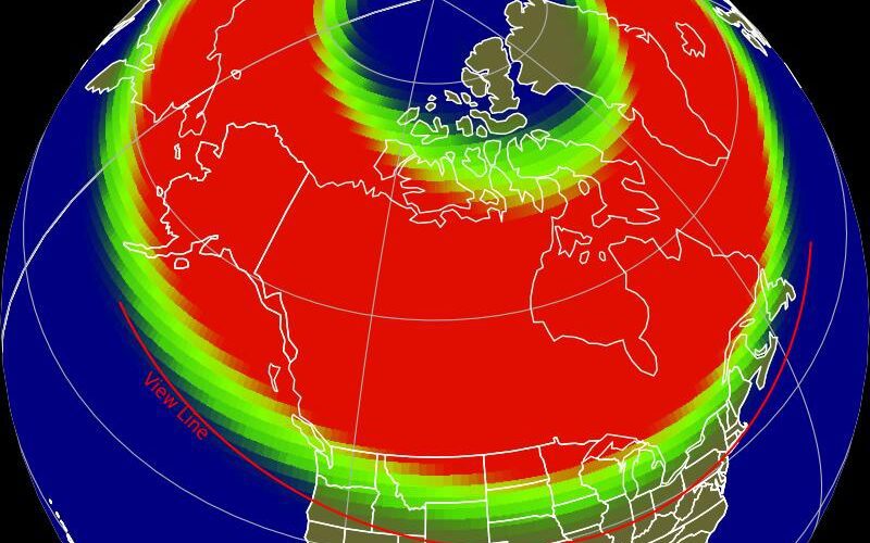
সৌরঝড়/মেরুজ্যোতির/অরোরা এর সৌন্দর্য পূর্ণ ভাবে উপভোগ করার জন্য আপনাকে শহরের বাহিরে যেতে হবে কিছুটা কারণ শহরের বৈদ্যুতিক আলোর কারণে স্পষ্ট দেখা যায় না বিভিন্ন বর্ণের আলো। নিচে একটি মানচিত্র যোগ করে দিলাম যে চিত্র নির্দেশ করতেছে পৃথিবীর কোন স্থানের মানুষরা কোন মানের সৌর ঝড় দেখতে পাবেন। যে স্থানের আকাশ যত বেশি মেঘ মুক্ত থাকবে সেই স্থান থেকে অরোরা বোরেলি তত বেশি সুন্দর দেখা যাবে।

সৌরঝড় এর শ্রেনীবিভাগ (শক্তির উপর ভিত্তি করে)
সমুদ্রের ঝড় যেমন হ্যারিকেন ঘণ্টায় বাতাস কত কিলোমিটার বেগে প্রবাহিত হচ্ছে তার উপর ভিত্তি করে ক্যাটেগরি ১, ২ থেকে সর্বোচ্চ ৫ মানের ঝড় হিসাবে চিহ্নিত করা হয় তেমনি সৌর ঝড়কে ১ থেকে ৫ মানের ক্যাটেগরিতে ভাগ করা হয় Geomagnetic Storms সমুদ্রের ঝড়ের ক্ষেত্রে যেমন বাতাসের গতিবেগকে ইনডিকেটর হিসাবে ধরে তেমনি সৌর ঝড়ের ক্ষেত্রে একটি ইনডিকেটর বা সূচক রয়েছে যাকে Kp-index বলে। এই সূচকের মান শূন্য (সর্বনিম্ন) থেকে ৯ (সর্বোচ্চ) পর্যন্ত ধরা হয়। ৯ মানের ঝড় গড়ে ২০ থেকে ৩০ বছরের মধ্যে মাত্র ১ বার হয়ে থাকে। আজকের সৌর ঝড়টির সূচক পূর্বাভাষ করা হয়েছে ৯ মানের। এই সূচকের ঝড়ও ক্যাটেগরি ৫ মানের সৌর ঝড় হিসাবে বিবেচিত হয়।
NOAA SPACE WEATHER SCALES: The K-index
[The K-index is used to characterize the magnitude of geomagnetic storms. The Kp-index describes the disturbance of the Earth’s magnetic field caused by the solar wind. The faster the solar wind blows, the greater the turbulence. The Kp-index is a global auroral activity indicator on a scale from 0 to 9. NOAA Space Weather Prediction Center (SWPC) forecasted a Kp-index for today’s storm. A Kp-index 7 means aurora can be as visible as far south as the yellow line. ]
আমেরিকার NATIONAL OCEANIC AND ATMOSPHERIC ADMINISTRATION কর্তৃক পরিচালিত SPACE WEATHER PREDICTION CENTER সেন্টারের নিম্নোক্ত ওয়েবসাইট থেকে ৩০ মিনিট পূর্বেই অরোরার পূর্বাভাষ পাওয়া যায়।

আমেরিকার NATIONAL OCEANIC AND ATMOSPHERIC ADMINISTRATION কর্তৃক পরিচালিত SPACE WEATHER PREDICTION CENTER সেন্টার কর্তৃক পরিচালিত ওয়েবসাইট এর SPACE WEATHER ENTHUSIASTS DASHBOARD থেকে সৌরঝড়/মেরুজ্যোতির/অরোরা বোরেলি (উত্তর মেরুর উপর সৃষ্টি হওয়া অরোরা)/অরোরা অস্ট্রেলি (দক্ষিন মেরুর উপর সৃষ্টি হওয়া অরোরা) এর বিভিন্ন বৈশিষ্ট সম্বন্ধে বিস্তারিত তথ্য পাওয়া যাবে।
=========================================
মেরুজ্যোতির/অরোরা বোরেলি সম্বন্ধে নিম্নোক্ত ইংরেজি বর্ণনা টি সংগৃহীত হয়েছে আমেরিকার NATIONAL OCEANIC AND ATMOSPHERIC ADMINISTRATION কর্তৃক পরিচালিত SPACE WEATHER PREDICTION CENTER সেন্টারের নিম্নোক্ত ওয়েবসাইট থেকে
=========================================================================
“The Aurora Borealis (Northern Lights) and Aurora Australis (Southern Lights) are the result of electrons colliding with the upper reaches of Earth’s atmosphere. (Protons cause faint and diffuse aurora, usually not easily visible to the human eye.) The electrons are energized through acceleration processes in the downwind tail (night side) of the magnetosphere and at lower altitudes along auroral field lines. The accelerated electrons follow the magnetic field of Earth down to the Polar Regions where they collide with oxygen and nitrogen atoms and molecules in Earth’s upper atmosphere. In these collisions, the electrons transfer their energy to the atmosphere thus exciting the atoms and molecules to higher energy states. When they relax back down to lower energy states, they release their energy in the form of light. This is similar to how a neon light works. The aurora typically forms 80 to 500 km above Earth’s surface.
Earth’s magnetic field guides the electrons such that the aurora forms two ovals approximately centered at the magnetic poles. During major geomagnetic storms these ovals expand away from the poles such that aurora can be seen over most of the United States. Aurora comes in several different shapes. Often the auroral forms are made of many tall rays that look much like a curtain made of folds of cloth. During the evening, these rays can form arcs that stretch from horizon to horizon. Late in the evening, near midnight, the arcs often begin to twist and sway, just as if a wind were blowing on the curtains of light. At some point, the arcs may expand to fill the whole sky, moving rapidly and becoming very bright. This is the peak of what is called an auroral substorm.
Then in the early morning the auroral forms can take on a more cloud-like appearance. These diffuse patches often blink on and off repeatedly for hours, then they disappear as the sun rises in the east. The best place to observe the aurora is under an oval shaped region between the north and south latitudes of about 60 and 75 degrees. At these polar latitudes, the aurora can be observed more than half of the nights of a given year.
When space weather activity increases and more frequent and larger storms and substorms occur, the aurora extends equatorward. During large events, the aurora can be observed as far south as the US, Europe, and Asia. During very large events, the aurora can be observed even farther from the poles. (Tips on viewing the aurora and maps of the typical extent of the aurora). Of course, to observe the aurora, the skies must be clear and free of clouds. It must also be dark so during the summer months at auroral latitudes, the midnight sun prevents auroral observations. Photo by Neal Brown (Fairbanks)”
সৌর ঝড় কোন সময় কোন স্থান থেকে কেমন দেখা যাবে তার জন্য “Aurora” নামক একটি ফ্রি আ্যাপ রয়েছে যা নিজের মোবাইলে ইন্সটল করে নিতে পারেন। সৌর ঝড় নিয়ে অনেক কুসংস্কার প্রচলিত থাকলেও সেগুলোর কোন বৈজ্ঞানিক ভিত্তি নাই। আমেরিকান মহাকাশ গবেষণা সংস্থার ওয়েবসাইট থেকে বিস্তারিত বৈজ্ঞানিক ব্যাখ্যা জেনে নিতে পারেন।
ওয়েবসাইটের তথ্য ব্যবহারের শর্তাবলী
১) এই ওয়েবসাইট থেকে সংগৃহীত কোন তথ্য কোন প্রকাশনায় (যেমন, সংবাদ পত্র, টেলিভিশন চ্যানেল, ফেসবুক, ব্লগ) ব্যবহার করলে আবহাওয়া ডট কম ওয়েবসাইটের নাম কিংবা মোস্তফা কামাল পলাশ (আবহাওয়া ও জলবায়ু গবেষক, সাস্কাচোয়ান বিশ্ববিদ্যালয়, সাসকাটুন, কানাডা) এর নাম তথ্য সূত্র হিসাবে উল্লেখ করা আবশ্যক।
২) এই ওয়েবসাইটে প্রচারিত সকল আবহাওয়া পূর্বাভাস বেসরকারি তথ্য হিসাবে গ্রহণ করতে হবে। এই ওয়েবসাইটে প্রচারিত আবহাওয়া পূর্বাভাসের তথ্য ব্যবহার করে কোন ব্যক্তি বা প্রতিষ্ঠান নীতি নির্ধারণই সিদ্ধান্ত গ্রহণ করে ক্ষতিগ্রস্ত হলে ওয়বেসাইটের সাথে জড়িত কোন ব্যক্তি দায়ী থাকিবে না।


